


Pagasa: LPA off Mindanao now a tropical depression
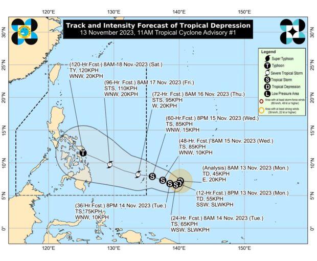
The low-pressure area (LPA) nearing the Philippine area of responsibility (PAR) is now a tropical depression, according to the Philippine Atmospheric, Geophysical and Astronomical Services Administration (Pagasa). In its bulletin issued 11 a.m. on Monday, November 13, 2023, Pagasa said the tropical depression was last located 1,540 kilometers east of southeastern Mindanao, packing maximum sustained winds of 45 kilometers per hour (kph) and gustiness of 55 kph. It will be named “Kabayan” once it enters the PAR, possibly by Wednesday, November 15. Photo from Pagasa’s website
MANILA, Philippines — The state weather bureau said Monday that the low-pressure area (LPA) nearing the Philippine area of responsibility (PAR) has strengthened into a tropical depression.
Based on the 11 a.m. bulletin of the Philippine Atmospheric, Geophysical and Astronomical Services Administration (Pagasa), the tropical depression was last located 1,540 kilometers east of southeastern Mindanao, packing maximum sustained winds of 45 kilometers per hour (kph) and gustiness of 55 kph.
The cyclone was moving eastward at 20 kph.
“On the track forecast, the tropical depression may enter the PAR region late Wednesday,” Pagasa said in an advisory sent to reporters.
It will be named “Kabayan” once it enters the PAR, it added.
READ: LPA nearing PH may turn into tropical depression within 24 hrs – Pagasa
As of the latest weather bulletin, the tropical depression was seen to follow a south-southwestward movement in the next 12 hours before turning west-southwestward.
It will then move west-northwestward while gradually accelerating as it nears the eastern boundary of the PAR, according to Pagasa.
“It will then turn further west-northwestward or westward on Thursday (16 November) on a steady pace towards the coast of eastern Visayas,” the state weather agency also said.
Pagasa’s bulletin likewise noted that the tropical depression may reach the typhoon category on Saturday, November 18.
Pagasa said that days before that, or starting Thursday, rough to very rough seas may be expected over the eastern seaboards of Mindanao.
RELATED STORY
Ready for the chill? Pagasa says ‘amihan’ begins


